
Mapa topográfico Kerguelen Archipelago
Mapa interativo
Clique no mapa para exibir a altitude.
Sobre este mapa
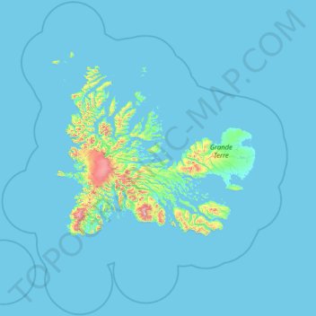
Nome: Mapa topográfico Kerguelen Archipelago, altitude, relevo.
Altitude média: 38 m
Altitude mínima: -2 m
Altitude máxima: 1451 m
Outros mapas topográficos
Clique em um mapa para visualizar sua topografia, sua altitude e seu relevo.
Pointe Goodenough
France > French Southern and Antarctic Lands
Pointe Goodenough, New Amsterdam Island, Saint Paul and New Amsterdam Islands, French Southern and Antarctic Lands, France
Altitude média: 40 m
Mont Pâris
France > French Southern and Antarctic Lands
Mont Pâris, Kerguelen Archipelago, French Southern and Antarctic Lands, France
Altitude média: 255 m
Possession Island
France > French Southern and Antarctic Lands
Possession Island, French Southern and Antarctic Lands, France
Altitude média: 13 m
New Amsterdam Island
France > French Southern and Antarctic Lands
New Amsterdam Island, Saint Paul and New Amsterdam Islands, French Southern and Antarctic Lands, France
Altitude média: 186 m
Cataractes
France > French Southern and Antarctic Lands
Cataractes, Kerguelen Archipelago, French Southern and Antarctic Lands, France
Altitude média: 31 m
Crozet Archipelago
France > French Southern and Antarctic Lands
Crozet Archipelago, French Southern and Antarctic Lands, France
Altitude média: 2 m
Penguin Island
France > French Southern and Antarctic Lands
Penguin Island, Crozet Archipelago, French Southern and Antarctic Lands, France
Altitude média: 48 m
Bassas da India
France > French Southern and Antarctic Lands
Bassas da India, Scattered Islands in the Indian Ocean, French Southern and Antarctic Lands, France
Altitude média: 0 m