
Mapa topográfico Monticello
Mapa interativo
Clique no mapa para exibir a altitude.
Sobre este mapa
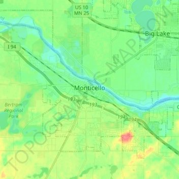
Nome: Mapa topográfico Monticello, altitude, relevo.
Local: Monticello, Wright County, Minnesota, 55362, United States (45.27053 -93.86106 45.33840 -93.73503)
Altitude média: 289 m
Altitude mínima: 270 m
Altitude máxima: 327 m
According to the U.S. Census Bureau, the city has a total area of 8.94 square miles (23.15 km2), all land. The city's latitude is 45.305 degrees North and its longitude is 93.793 degrees West. Its elevation is 922 feet. Monticello is in the Central time zone.
Outros mapas topográficos
Clique em um mapa para visualizar sua topografia, sua altitude e seu relevo.
Rockford
United States > Minnesota > Wright County
Rockford, Wright County, Minnesota, United States
Altitude média: 296 m
Delano
United States > Minnesota > Wright County
Delano, Wright County, Minnesota, 55328, United States
Altitude média: 289 m
Otsego
United States > Minnesota > Wright County
Otsego, Wright County, Minnesota, United States
Altitude média: 281 m
Monticello Township
United States > Minnesota > Wright County
Monticello Township, Wright County, Minnesota, United States
Altitude média: 297 m
Albertville
United States > Minnesota > Wright County
Albertville, Wright County, Minnesota, 55301, United States
Altitude média: 292 m
Hanover
United States > Minnesota > Wright County
Hanover, Wright County, Minnesota, 55341, United States
Altitude média: 291 m
Montrose
United States > Minnesota > Wright County
Montrose, Wright County, Minnesota, United States
Altitude média: 294 m
Howard Lake
United States > Minnesota > Wright County
Howard Lake, Wright County, Minnesota, 55349, United States
Altitude média: 312 m
Buffalo
United States > Minnesota > Wright County
Buffalo, Wright County, Minnesota, 55313, United States
Altitude média: 297 m
Silver Creek Township
United States > Minnesota > Wright County
Silver Creek Township, Wright County, Minnesota, 55380, United States
Altitude média: 303 m
Albion Center
United States > Minnesota > Wright County
Albion Center, Albion Township, Wright County, Minnesota, United States
Altitude média: 320 m
St. Michael
United States > Minnesota > Wright County
St. Michael, Wright County, Minnesota, 55376, United States
Altitude média: 290 m
Maple Lake Township
United States > Minnesota > Wright County
Maple Lake Township, Wright County, Minnesota, 55358, United States
Altitude média: 310 m
South Haven
United States > Minnesota > Wright County
South Haven, Wright County, Minnesota, United States
Altitude média: 333 m
Maple Lake
United States > Minnesota > Wright County > Maple Lake > Maple Lake
Maple Lake, Wright County, Minnesota, 55358, United States
Altitude média: 314 m
South Haven
United States > Minnesota > Wright County > South Haven > South Haven
South Haven, Wright County, Minnesota, 55382, United States
Altitude média: 331 m
Rockford
United States > Minnesota > Wright County > Rockford > Rockford
Rockford, Wright County, Minnesota, 55313:55373, United States
Altitude média: 298 m
Annandale
United States > Minnesota > Wright County > Annandale > Annandale
Annandale, Wright County, Minnesota, 55302, United States
Altitude média: 324 m
Annandale
United States > Minnesota > Wright County
Annandale, Wright County, Minnesota, 55302, United States
Altitude média: 323 m
Maple Lake
United States > Minnesota > Wright County
Maple Lake, Wright County, Minnesota, United States
Altitude média: 314 m