
Mapa topográfico Rhinecliff
Mapa interativo
Clique no mapa para exibir a altitude.
Rhinecliff
The hamlet is demarcated by large agricultural and wooded area to the north, east, and south, and bounded by the Hudson River on the west. Steep topography, formed by contorted slate ridges and valleys, define the site-specific and seemingly random orientation of the small, frame nineteenth-century houses and winding narrow roads. The hamlet had a mid-nineteenth century building boom, but its boundaries and building density have changed very little over the last one hundred years.
Sobre este mapa
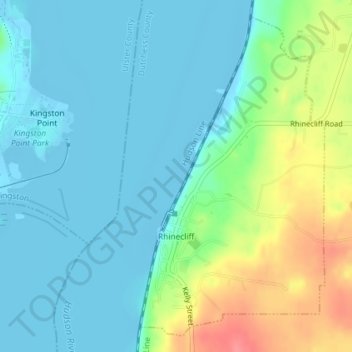
Nome: Mapa topográfico Rhinecliff, altitude, relevo.
Altitude média: 19 m
Altitude mínima: -9 m
Altitude máxima: 73 m
Outros mapas topográficos
Clique em um mapa para visualizar sua topografia, sua altitude e seu relevo.
Drayton Grant Park at Burger Hill
United States > New York > Dutchess County > Town of Rhinebeck
Altitude média: 102 m