
Mapa topográfico Hoogstede
Mapa interativo
Clique no mapa para exibir a altitude.
Sobre este mapa
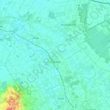
Nome: Mapa topográfico Hoogstede, altitude, relevo.
Altitude média: 18 m
Altitude mínima: 11 m
Altitude máxima: 66 m
Outros mapas topográficos
Clique em um mapa para visualizar sua topografia, sua altitude e seu relevo.
49849
Germany > Lower Saxony > Landkreis Grafschaft Bentheim > Wilsum
49849, Wilsum, Samtgemeinde Uelsen, Landkreis Grafschaft Bentheim, Lower Saxony, Germany
Altitude média: 25 m
Bad Bentheim
Germany > Lower Saxony > Landkreis Grafschaft Bentheim
Bad Bentheim, Landkreis Grafschaft Bentheim, Lower Saxony, 48455, Germany
Altitude média: 38 m