
Mapa topográfico Calgary
Mapa interativo
Clique no mapa para exibir a altitude.
Sobre este mapa
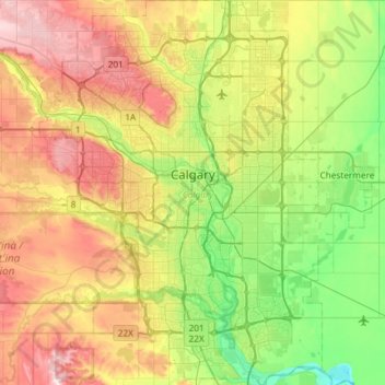
Nome: Mapa topográfico Calgary, altitude, relevo.
Local: Calgary, Alberta, Canada (50.84253 -114.31576 51.21250 -113.86000)
Altitude média: 1106 m
Altitude mínima: 957 m
Altitude máxima: 1349 m
Calgary experiences a humid continental climate (Köppen climate classification Dwb) within eastern parts of the city and a subarctic climate (Köppen climate classification Dwc) within western parts of the city due to an increase in elevation. The city has warm summers and cold, dry winters. It falls into the NRC Plant Hardiness Zone 4a. According to Environment Canada, average daily temperatures in Calgary range from 16.5 °C (61.7 °F) in July to −6.8 °C (19.8 °F) in December.
Outros mapas topográficos
Clique em um mapa para visualizar sua topografia, sua altitude e seu relevo.