Geolocalizar

Mapa topográfico Nottingham Canal

Clique no mapa para exibir a altitude.

Sobre este mapa

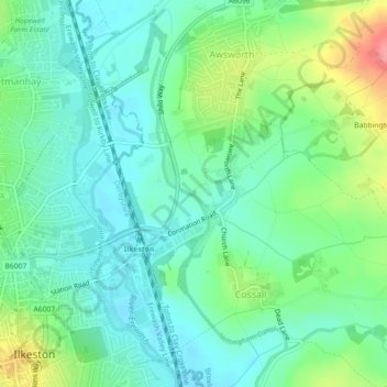
Nome: Mapa topográfico Nottingham Canal, altitude, relevo.

Local: Nottingham Canal, Cossall Marsh, Broxtowe, Nottinghamshire, England, NG16 2RU, United Kingdom (52.98218 -1.28875 52.98250 -1.28855)

Altitude média: 68 m

Altitude mínima: 43 m

Altitude máxima: 127 m

Outros mapas topográficos

Clique em um mapa para visualizar sua topografia, sua altitude e seu relevo.

Beeston

United Kingdom > England > Nottinghamshire > Broxtowe

Altitude média: 39 m

Trowell

United Kingdom > England > Nottinghamshire > Broxtowe

Altitude média: 62 m

Beeston

United Kingdom > England > Nottinghamshire > Broxtowe

Altitude média: 44 m

Brinsley

United Kingdom > England > Nottinghamshire > Broxtowe

Altitude média: 100 m

Greasley

United Kingdom > England > Nottinghamshire > Broxtowe

Altitude média: 104 m

River Erewash

United Kingdom > England > Nottinghamshire > Broxtowe

The approximate meaning of the name is not in doubt, but there is room for debate about the precise derivation and its connotations. Brewer gives the commonly accepted explanation that it comes from the Old English words irre ("wandering") and wisce ("wet meadow"). This is accepted by Kenneth Cameron, a…

Altitude média: 87 m

Nuthall

United Kingdom > England > Nottinghamshire > Broxtowe

Altitude média: 95 m

Cossall

United Kingdom > England > Nottinghamshire > Broxtowe

Altitude média: 70 m

Prepare-se para a sua próxima aventura:

🍖Refeições Liofilizadas para Outdoor - Comida leve e nutritiva que basta hidratar com água quente
🧰Kits de Primeiros Socorros - Segurança em trilhos e viagens
🗺️Mapas de Estradas de Portugal - Cartografia física atualizada para planeamento de viagens
🏔️Equipamento de Montanha - Preparação para terrenos exigentes
🪢Cordas Outdoor - Utilização versátil em campismo e trekking

Como Associado da Amazon, este site recebe uma comissão sobre compras elegíveis sem custo adicional para si.