
Mapa topográfico Trail
Clique no mapa para exibir a altitude.
Trail
Summer climate in Trail is generally hot and dry with moderately cool nights. Temperatures often exceed 35 °C (95 °F) during summer afternoons, average 29 °C (84 °F). Thunderstorms are common during the late-Spring and Summer season, often moving into the valley from the south. The fall months bring dense river fog, especially overnight and in the morning, as a cold air inversion lingers above the relatively warm river surface. Winters are mild to cold with periods of moderate snowfall. Nearby villages such as Warfield, Fruitvale and especially Rossland receive greater amounts of snow due to higher elevation.
Sobre este mapa
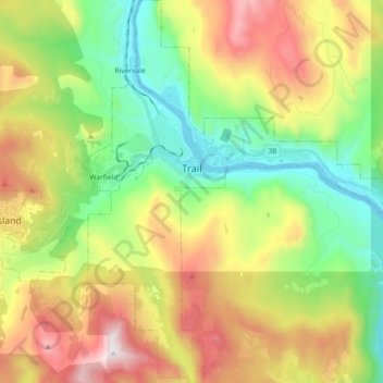
Nome: Mapa topográfico Trail, altitude, relevo.
Altitude média: 888 m
Altitude mínima: 395 m
Altitude máxima: 1637 m
Outros mapas topográficos
Clique em um mapa para visualizar sua topografia, sua altitude e seu relevo.
Stump Lake
Canada > British Columbia > Regional District of Kootenay Boundary > Area E (Beaverdell/West Boundary)
Altitude média: 1321 m