
Mapa topográfico Hacklebarney
Mapa interativo
Clique no mapa para exibir a altitude.
Sobre este mapa
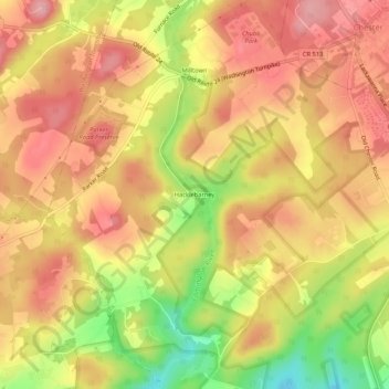
Nome: Mapa topográfico Hacklebarney, altitude, relevo.
Altitude média: 230 m
Altitude mínima: 142 m
Altitude máxima: 283 m
Outros mapas topográficos
Clique em um mapa para visualizar sua topografia, sua altitude e seu relevo.
Hacklebarney State Park
United States of America > New Jersey > Chester Township > Hacklebarney
Hacklebarney State Park, State Park Road, Hacklebarney, Chester Township, Morris County, New Jersey, 07955, United States of America
Altitude média: 166 m