
Mapa topográfico Bengaluru
Mapa interativo
Clique no mapa para exibir a altitude.
Bengaluru
Bengaluru (formerly Bangalore) is situated in the southeastern part of Karnataka, India, within the Bengaluru Urban district. It lies at an elevation of approximately 900 meters (3,000 feet) above sea level, on the Deccan Plateau. This elevated position gives the city a moderate climate, with temperatures rarely reaching extremes. The terrain around Bengaluru is characterized by rolling hills, rocky outcrops, and lush greenery, particularly on the outskirts. While the city itself is relatively flat, the surrounding landscape includes small hills and valleys, especially in areas like the Nandi Hills to the north, which is a prominent feature of the region’s topography. The city's varied elevation adds to its scenic beauty, offering expansive views of the countryside, lakes, and parks that dot the landscape. The mix of urban development and natural topography makes Bengaluru's setting unique in terms of both natural and man-made features.
Sobre este mapa
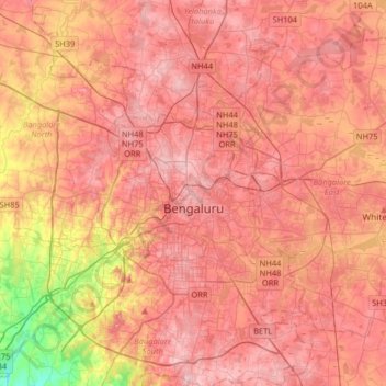
Nome: Mapa topográfico Bengaluru, altitude, relevo.
Local: Bengaluru, Bangalore North, Bengaluru Urban, Karnataka, India (12.83363 77.46005 13.14266 77.78436)
Altitude média: 886 m
Altitude mínima: 731 m
Altitude máxima: 965 m
Outros mapas topográficos
Clique em um mapa para visualizar sua topografia, sua altitude e seu relevo.
Bengaluru
India > Karnataka > Bangalore North
Bangalore (/ˈbæŋɡəlɔːr, ˌbæŋɡəˈlɔːr/ BANG-gə-lor, -LOR), officially Bengaluru (Kannada: [ˈbeŋɡɐɭuːɾu] ; ISO: Beṁgaḷūru), is the capital and largest city of the southern Indian state of Karnataka. It has a population of more than 8 million and a metropolitan population of around…
Altitude média: 879 m