
Mapa topográfico Gifford Pinchot National Forest
Mapa interativo
Clique no mapa para exibir a altitude.
Sobre este mapa
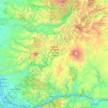
Nome: Mapa topográfico Gifford Pinchot National Forest, altitude, relevo.
Altitude média: 769 m
Altitude mínima: -1 m
Altitude máxima: 3703 m
Gifford Pinchot National Forest is located in a mountainous region approximately between Mount St. Helens to the west, Mount Adams to the east, Mount Rainier National Park to the north, and the Columbia River to the south. This region of Southwest Washington is noted for its complex topography and volcanic geology. About 65 percent of the forest acreage is located in Skamania County. In descending order of land area the others are Lewis, Yakima, Cowlitz, and Klickitat counties.
Outros mapas topográficos
Clique em um mapa para visualizar sua topografia, sua altitude e seu relevo.
Spirit Lake
United States > Washington > Skamania County
Spirit Lake, Skamania County, Washington, United States
Altitude média: 1144 m
Mount Saint Helens
United States > Washington > Skamania County
Mount Saint Helens, Skamania County, Washington, United States
Altitude média: 2096 m