
Mapa topográfico Brinkum
Mapa interativo
Clique no mapa para exibir a altitude.
Sobre este mapa
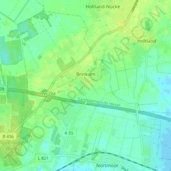
Nome: Mapa topográfico Brinkum, altitude, relevo.
Altitude média: 7 m
Altitude mínima: -2 m
Altitude máxima: 14 m
Outros mapas topográficos
Clique em um mapa para visualizar sua topografia, sua altitude e seu relevo.
Veenhusen
Germany > Lower Saxony > Landkreis Leer
Veenhusen, Moormerland, Landkreis Leer, Lower Saxony, 26802, Germany
Altitude média: 4 m
Schatteburg
Germany > Lower Saxony > Landkreis Leer > Backemoor > Schatteburg
Schatteburg, Backemoor, Rhauderfehn, Landkreis Leer, Lower Saxony, Germany
Altitude média: 3 m
Borkum
Germany > Lower Saxony > Landkreis Leer > Borkum
Borkum, Landkreis Leer, Lower Saxony, Germany
Altitude média: 0 m