
Mapa topográfico Kapuskasing
Clique no mapa para exibir a altitude.
Kapuskasing
Kapuskasing lies in the heart of the Great Clay Belt. The topography of the region is very flat, dotted with numerous small lakes and muskeg bogs. Also in the heart of Canada's boreal forest, the region is drained by rivers running north to James Bay. The district is heavily forested, mostly by thick stands of black spruce that have commercial value as pulpwood.
Sobre este mapa
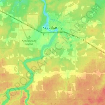
Nome: Mapa topográfico Kapuskasing, altitude, relevo.
Altitude média: 227 m
Altitude mínima: 202 m
Altitude máxima: 249 m
Outros mapas topográficos
Clique em um mapa para visualizar sua topografia, sua altitude e seu relevo.