
Mapa topográfico Hodh Ech Chargui
Mapa interativo
Clique no mapa para exibir a altitude.
Sobre este mapa
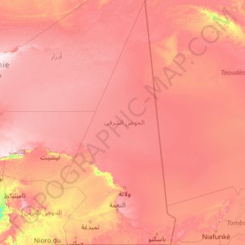
Nome: Mapa topográfico Hodh Ech Chargui, altitude, relevo.
Local: Hodh Ech Chargui, Mauritania (15.49978 -9.14969 23.15823 -5.33333)
Altitude média: 300 m
Altitude mínima: 105 m
Altitude máxima: 579 m
Mauritania is mostly covered with desert, with only its western regions around the coast of Atlantic Ocean having some vegetation. There are some oasis in the desert regions. Since it is a desert, there are large shifting dunes forming temporary ranges. The average elevation is around 460 m (1,510 ft) above the mean sea level. The northern regions closer to the Tropic of Cancer receive around 100 mm (3.9 in) of annual rainfall compared to the southern portions that receive around 660 mm (26 in). The average temperature is 37.8 °C (100.0 °F), while during winter nights it may even reach 0 °C (32 °F). Due to the geography, the inhabitants historically, have been nomadic. In modern times, people have migrated to urban centres during the drought in 1970 and 1980. There are a few sedentary cultivators, who are located only in the Southern regions of the country. Research has indicated that the Saharan movement has resulted in reduction of rains in the region from the 1960s, when it received close to 250 mm (9.8 in) of rainfall. From 1 September to 8 September 2020, torrential rains topping 100mm fell near the border with Mali, causing widespread damage, particularly in the Bassiknou department.
Outros mapas topográficos
Clique em um mapa para visualizar sua topografia, sua altitude e seu relevo.
Gleib Teintane
Gleib Teintane, Tiris Zemmour, Mauritania
Altitude média: 342 m
Nouakchott
Mauritania > Nouakchott-Ouest Region
Nouakchott, Nouakchott-Ouest Region, Mauritania
Altitude média: 4 m
Aracham Abiod
Aracham Abiod, Tiris Zemmour, Mauritania
Altitude média: 445 m
Kediet ej Jill
Kediet ej Jill, Tiris Zemmour, Mauritania
Altitude média: 783 m