
Mapa topográfico Wading River
Mapa interativo
Clique no mapa para exibir a altitude.
Sobre este mapa
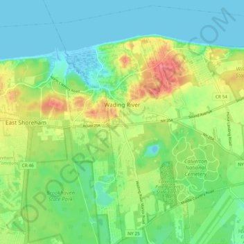
Nome: Mapa topográfico Wading River, altitude, relevo.
Altitude média: 23 m
Altitude mínima: -4 m
Altitude máxima: 66 m
The earliest English records show a settlement known as Wading River was founded by eight colonial families. "The spot for the village was chosen with care. There was a stream adequate for water power and abounding in seafood...good water for drinking...soil rich enough to grow essential crops, woodland for fuel, building material and food, topography to offer protection from the elements, meadowland for its grass."
Outros mapas topográficos
Clique em um mapa para visualizar sua topografia, sua altitude e seu relevo.
Riverhead
United States > New York > Suffolk County > Town of Riverhead
Riverhead, Town of Riverhead, Suffolk County, New York, United States
Altitude média: 13 m
Calverton
United States > New York > Suffolk County > Town of Riverhead
Calverton, Town of Riverhead, Suffolk County, New York, 11933, United States
Altitude média: 26 m