
Mapa topográfico Grand Portage National Monument
Mapa interativo
Clique no mapa para exibir a altitude.
Sobre este mapa
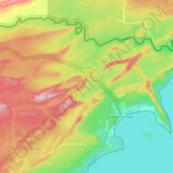
Nome: Mapa topográfico Grand Portage National Monument, altitude, relevo.
Altitude média: 314 m
Altitude mínima: 163 m
Altitude máxima: 525 m
The portage begins on Lake Superior, elevation 600 feet (180 m), rising as it moves westward through two notches in the Sawtooth Mountain range. It briefly levels off around 1,000 feet (300 m) after 2.6 miles (4.2 km). Another 1.5 miles (2.4 km) you reach the inland county highway. From here, the trail is more level, rising to 1,300 feet (400 m), the highest location on the trail, before dropping back to 1,260 feet (380 m) at Fort Charlotte on the Pigeon River. The trail's high point is the head of a drainage flowing to the Pigeon River at Fort Charlotte. The headwaters has become a large beaver pond. The dam is located along the trail route and has a boardwalk atop it, added for modern visitors.
Outros mapas topográficos
Clique em um mapa para visualizar sua topografia, sua altitude e seu relevo.
Schroeder
United States > Minnesota > Cook County
Schroeder, Schroeder Township, Cook County, Minnesota, United States
Altitude média: 235 m
Grand Marais
United States > Minnesota > Cook County
Grand Marais, Cook County, Minnesota, United States
Altitude média: 280 m
Magic Lake
United States > Minnesota > Cook County
Magic Lake, Schroeder Township, Cook County, Minnesota, United States
Altitude média: 564 m
Ptarmigan Lake
United States > Minnesota > Cook County
Ptarmigan Lake, West Cook, Cook County, Minnesota, United States
Altitude média: 612 m
Lutsen
United States > Minnesota > Cook County
Lutsen, Lutsen Township, Cook County, Minnesota, 55612, United States
Altitude média: 225 m
Cherokee Lake
United States > Minnesota > Cook County
Cherokee Lake, Cook County, Minnesota, United States
Altitude média: 565 m
Olso Lake
United States > Minnesota > Cook County
Olso Lake, Cook County, Minnesota, United States
Altitude média: 544 m
Hovland
United States > Minnesota > Cook County
Hovland, East Cook, Cook County, Minnesota, 56606, United States
Altitude média: 226 m
Ball Club Lake
United States > Minnesota > Cook County
Ball Club Lake, Cook County, Minnesota, United States
Altitude média: 610 m
Tofte
United States > Minnesota > Cook County
Tofte, Tofte Township, Cook County, Minnesota, 55613, United States
Altitude média: 223 m
Flour Lake
United States > Minnesota > Cook County
Flour Lake, Cook County, Minnesota, United States
Altitude média: 535 m
Grand Portage
United States > Minnesota > Cook County
Grand Portage, Cook County, Minnesota, 55605, United States
Altitude média: 257 m
Eagle Mountain
United States > Minnesota > Cook County
Eagle Mountain, Cook County, Minnesota, United States
Altitude média: 596 m
Chippewa City
United States > Minnesota > Cook County > Chippewa City
Chippewa City, Cook County, Minnesota, United States
Altitude média: 238 m
Potato Lake
United States > Minnesota > Cook County
Potato Lake, East Cook, Cook County, Minnesota, United States
Altitude média: 621 m