
Mapa topográfico Bonneberg
Mapa interativo
Clique no mapa para exibir a altitude.
Sobre este mapa
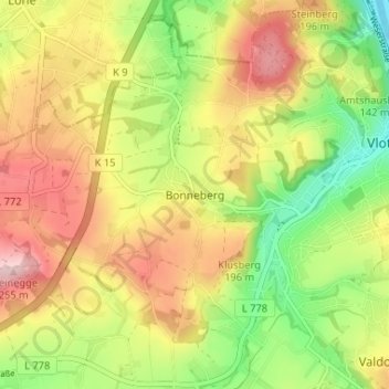
Nome: Mapa topográfico Bonneberg, altitude, relevo.
Altitude média: 150 m
Altitude mínima: 44 m
Altitude máxima: 258 m
Outros mapas topográficos
Clique em um mapa para visualizar sua topografia, sua altitude e seu relevo.
Vlotho
Deutschland > Nordrhein-Westfalen > Kreis Herford > Vlotho
Vlotho, Kreis Herford, Nordrhein-Westfalen, 32602, Deutschland
Altitude média: 119 m
NSG Eiberg
Deutschland > Nordrhein-Westfalen > Kreis Herford > Vlotho
NSG Eiberg, Lemgoer Straße, Beerenkämpen, Valdorf, Vlotho, Kreis Herford, Nordrhein-Westfalen, 32602, Deutschland
Altitude média: 166 m
Uffeln
Deutschland > Nordrhein-Westfalen > Kreis Herford > Vlotho
Uffeln, Vlotho, Kreis Herford, Nordrhein-Westfalen, Deutschland
Altitude média: 104 m
Exter
Deutschland > Nordrhein-Westfalen > Kreis Herford > Vlotho
Exter, Vlotho, Kreis Herford, Nordrhein-Westfalen, Deutschland
Altitude média: 159 m