
Faça uma doação
Prepare-se para a sua próxima aventura:
Como Associado da Amazon, este site recebe uma comissão sobre compras elegíveis sem custo adicional para si.
Mapa topográfico Langstone
Clique no mapa para exibir a altitude.
Faça uma doação
Prepare-se para a sua próxima aventura:
Como Associado da Amazon, este site recebe uma comissão sobre compras elegíveis sem custo adicional para si.
Sobre este mapa
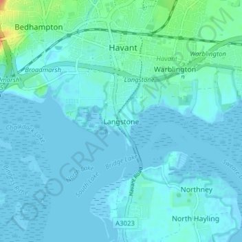
Nome: Mapa topográfico Langstone, altitude, relevo.
Local: Langstone, Havant, Hampshire, England, PO9 1RF, United Kingdom (50.81974 -1.00261 50.85974 -0.96261)
Altitude média: 5 m
Altitude mínima: -4 m
Altitude máxima: 37 m
Faça uma doação
Prepare-se para a sua próxima aventura:
Como Associado da Amazon, este site recebe uma comissão sobre compras elegíveis sem custo adicional para si.
Outros mapas topográficos
Clique em um mapa para visualizar sua topografia, sua altitude e seu relevo.
Hayling Island
United Kingdom > England > Hampshire > Havant > North Hayling
An Iron Age shrine in the north of Hayling Island was later developed into a Roman temple in the 1st century BC and was first recorded in Richard Scott's Topographical and Historical Account of Hayling Island (1826). The site was dug between 1897 and 1907 and again from 1976 to 1978. The remains are now buried…
Altitude média: 1 m
Hayling Island
United Kingdom > England > Hampshire > Havant > Fleet
An Iron Age shrine in the north of Hayling Island was later developed into a Roman temple in the 1st century BC and was first recorded in Richard Scott's Topographical and Historical Account of Hayling Island (1826). The site was dug between 1897 and 1907 and again from 1976 to 1978. The remains are now buried…
Altitude média: 1 m
Faça uma doação
Prepare-se para a sua próxima aventura:
Como Associado da Amazon, este site recebe uma comissão sobre compras elegíveis sem custo adicional para si.