
Faça uma doação
Prepare-se para a sua próxima aventura:
Como Associado da Amazon, este site recebe uma comissão sobre compras elegíveis sem custo adicional para si.
Mapa topográfico Duzduzan
Clique no mapa para exibir a altitude.
Faça uma doação
Prepare-se para a sua próxima aventura:
Como Associado da Amazon, este site recebe uma comissão sobre compras elegíveis sem custo adicional para si.
Duzduzan
Duzduzan is located in the mountains of Arasbaran in north-western Iran on the highway between Ardabil and Tabriz. Although not on the river it is within the drainage basin of the Aji Chay. Because of its high elevation it has a climate that is generally cold and rainy. The city is 15 km by road east of the village of Kurdkandi and 32 km by road east of Bostanabad. Duzduzan is 37 km by road west of the city of Sarab, the county seat.
Faça uma doação
Prepare-se para a sua próxima aventura:
Como Associado da Amazon, este site recebe uma comissão sobre compras elegíveis sem custo adicional para si.
Sobre este mapa
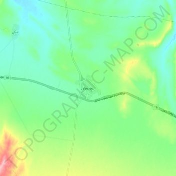
Nome: Mapa topográfico Duzduzan, altitude, relevo.
Altitude média: 1672 m
Altitude mínima: 1624 m
Altitude máxima: 1786 m
Faça uma doação
Prepare-se para a sua próxima aventura:
Como Associado da Amazon, este site recebe uma comissão sobre compras elegíveis sem custo adicional para si.