
Faça uma doação
Prepare-se para a sua próxima aventura:
Como Associado da Amazon, este site recebe uma comissão sobre compras elegíveis sem custo adicional para si.
Mapa topográfico Mount Patterson
Clique no mapa para exibir a altitude.
Faça uma doação
Prepare-se para a sua próxima aventura:
Como Associado da Amazon, este site recebe uma comissão sobre compras elegíveis sem custo adicional para si.
Sobre este mapa
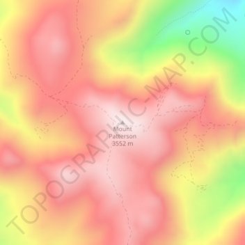
Nome: Mapa topográfico Mount Patterson, altitude, relevo.
Local: Mount Patterson, Mono County, California, United States (38.43653 -119.30521 38.43663 -119.30511)
Altitude média: 3309 m
Altitude mínima: 2835 m
Altitude máxima: 3558 m
Faça uma doação
Prepare-se para a sua próxima aventura:
Como Associado da Amazon, este site recebe uma comissão sobre compras elegíveis sem custo adicional para si.
Outros mapas topográficos
Clique em um mapa para visualizar sua topografia, sua altitude e seu relevo.
Mammoth Lakes
United States > California > Mono County
Mammoth Lakes is a town in Mono County, California, and is the county's only incorporated community. It is located immediately to the east of Mammoth Mountain, at an elevation of 7,880 feet (2,400 m). As of the 2020 United States Census, the population was 7,191, reflecting a 12.7% decrease from the 2010…
Altitude média: 2682 m
June Lake
United States > California > Mono County > June Lake
Because the community is built on hills and meadows in this subalpine valley surrounded by high mountain peaks, it has been dubbed the "Switzerland of California." The area is notable for its trout fishing. Hiking is a favorite pastime of the area: June Lake offers many trails that lead into the nearby back…
Altitude média: 2531 m
Faça uma doação
Prepare-se para a sua próxima aventura:
Como Associado da Amazon, este site recebe uma comissão sobre compras elegíveis sem custo adicional para si.
Faça uma doação
Prepare-se para a sua próxima aventura:
Como Associado da Amazon, este site recebe uma comissão sobre compras elegíveis sem custo adicional para si.
Mammoth Lakes
United States > California > Mono County
Mammoth Lakes is the only incorporated town in Mono County, California, United States. It is located immediately to the east of Mammoth Mountain, at an elevation of 7,880 feet (2,400 m). As of the 2020 United States census, the population was 7,191, reflecting a 12.7% decrease from the 2010 Census.
Altitude média: 2682 m
Mammoth Lakes
United States > California > Mono County
Mammoth Lakes is a town in Mono County, California, and is the county's only incorporated community. It is located immediately to the east of Mammoth Mountain, at an elevation of 7,880 feet (2,400 m). As of the 2020 United States Census, the population was 7,191, reflecting a 12.7% decrease from the 2010…
Altitude média: 2682 m
June Lake
United States > California > Mono County > June Lake
June Lake is a census-designated place in Mono County, California. It is located against the southern rim of the Mono Basin, 12.5 miles (20 km) south of Lee Vining, at an elevation of 7654 feet (2333 m).
Altitude média: 2445 m
Bridgeport
United States > California > Mono County > Bridgeport
Bridgeport is in northwestern Mono County and lies at an elevation of 6,463 feet (1,970 m) in the middle of the Bridgeport Valley. The valley is ringed by mountains with the Sierra Nevada to the west, the Sweetwater Mountains to the north, and the Bodie Hills to the east.
Altitude média: 2074 m
Faça uma doação
Prepare-se para a sua próxima aventura:
Como Associado da Amazon, este site recebe uma comissão sobre compras elegíveis sem custo adicional para si.
Mono Lake
United States > California > Mono County
Lake Russell was the prehistoric predecessor to Mono Lake, during the Pleistocene. Its shoreline reached the modern-day elevation of 7,480 feet (2,280 m), about 1,100 feet (330 m) higher than the present-day lake. As of 1.6 million years ago, Lake Russell discharged to the northeast, into the Walker River…
Altitude média: 2008 m
Faça uma doação
Prepare-se para a sua próxima aventura:
Como Associado da Amazon, este site recebe uma comissão sobre compras elegíveis sem custo adicional para si.