
Mapa topográfico Unggenried
Mapa interativo
Clique no mapa para exibir a altitude.
Sobre este mapa
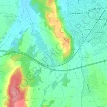
Nome: Mapa topográfico Unggenried, altitude, relevo.
Altitude média: 623 m
Altitude mínima: 595 m
Altitude máxima: 694 m
Outros mapas topográficos
Clique em um mapa para visualizar sua topografia, sua altitude e seu relevo.
Mindelau
Deutschland > Bayern > Landkreis Unterallgäu > Mindelheim
Mindelau, Mindelheim, Landkreis Unterallgäu, Bayern, 87742, Deutschland
Altitude média: 644 m
Doldenhausen
Deutschland > Bayern > Landkreis Unterallgäu > Mindelheim
Doldenhausen, Mindelheim, Landkreis Unterallgäu, Bayern, 87719, Deutschland
Altitude média: 597 m