
Mapa topográfico Joyford
Mapa interativo
Clique no mapa para exibir a altitude.
Sobre este mapa
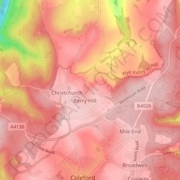
Nome: Mapa topográfico Joyford, altitude, relevo.
Altitude média: 188 m
Altitude mínima: 17 m
Altitude máxima: 237 m
Outros mapas topográficos
Clique em um mapa para visualizar sua topografia, sua altitude e seu relevo.
Lower Berry Hill
United Kingdom > England > Gloucestershire > Forest of Dean > Berry Hill
Lower Berry Hill, Coleford, Berry Hill, Forest of Dean, Gloucestershire, England, GL16 8QF, United Kingdom
Altitude média: 193 m