
Mapa topográfico Kelowna
Mapa interativo
Clique no mapa para exibir a altitude.
Sobre este mapa
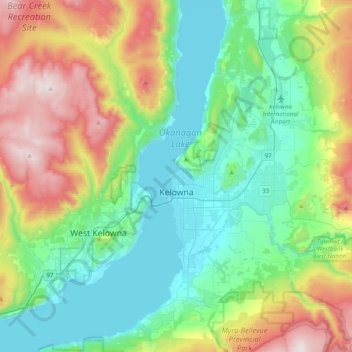
Nome: Mapa topográfico Kelowna, altitude, relevo.
Altitude média: 704 m
Altitude mínima: 335 m
Altitude máxima: 1576 m
Kelowna is classified as a humid continental climate or an inland oceanic climate per the Köppen climate classification system due to its coldest month having an average temperature slightly above −3.0 °C (26.6 °F) and below 0 °C (32 °F), with dry, hot, sunny summers and cool, cloudy winters, and four seasons. The official climate station for Kelowna is at the Kelowna International Airport, which is at a higher elevation than the city core, with slightly higher precipitation and cooler nighttime temperatures. Kelowna has the second mildest winter of any non-coastal city in Canada, after neighbouring Penticton. This is caused by the moderating effects of Okanagan Lake combined with mountains separating most of BC from the prairies; however Arctic air masses do occasionally penetrate the valley during winter, usually for very short periods. The coldest recorded temperature in the city was −36.1 °C (−33.0 °F) recorded on 30 December 1968.
Outros mapas topográficos
Clique em um mapa para visualizar sua topografia, sua altitude e seu relevo.
Thompson Plateau
Canada > British Columbia > Regional District of Central Okanagan > East Central Okanagan Electoral Area
Thompson Plateau, East Central Okanagan Electoral Area, Regional District of Central Okanagan, British Columbia, Canada
Altitude média: 1451 m
Okanagan Lake
Canada > British Columbia > Regional District of Central Okanagan > Kelowna
Okanagan Lake, Kelowna, Westbank First Nation #9, Regional District of Central Okanagan, British Columbia, Canada
Altitude média: 1194 m
Lake Country
Canada > British Columbia > Regional District of Central Okanagan
Lake Country, Regional District of Central Okanagan, British Columbia, Canada
Altitude média: 650 m
Kangaroo
Canada > British Columbia > Regional District of Central Okanagan > East Central Okanagan Electoral Area
Kangaroo, East Central Okanagan Electoral Area, Regional District of Central Okanagan, British Columbia, Canada
Altitude média: 458 m
Peachland
Canada > British Columbia > Regional District of Central Okanagan
Peachland, Regional District of Central Okanagan, British Columbia, Canada
Altitude média: 628 m