
Mapa topográfico Mullan
Mapa interativo
Clique no mapa para exibir a altitude.
Sobre este mapa
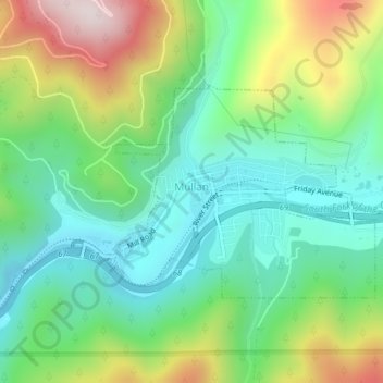
Nome: Mapa topográfico Mullan, altitude, relevo.
Local: Mullan, Shoshone County, Idaho, 83846, United States (47.46237 -115.81073 47.47740 -115.78263)
Altitude média: 1168 m
Altitude mínima: 962 m
Altitude máxima: 1577 m
In Shoshone County at the east end of the Silver Valley, Mullan is in a sheltered canyon of the Coeur d'Alene Mountains at an elevation of 3,278 feet (1,000 m) above sea level. The entrance to the Lucky Friday mine is several hundred yards east of the city center; the active mine (silver, lead, & zinc) descends more than six thousand feet (1.1 mi; 1.8 km) below the surface.
Outros mapas topográficos
Clique em um mapa para visualizar sua topografia, sua altitude e seu relevo.
Devils Pulpit
United States > Idaho > Shoshone County
Devils Pulpit, Shoshone County, Idaho, United States
Altitude média: 1116 m
Canyon Peak
United States > Idaho > Shoshone County
Canyon Peak, Shoshone County, Idaho, United States
Altitude média: 1203 m
Wallace
United States > Idaho > Shoshone County
Wallace, Shoshone County, Idaho, 83873, United States
Altitude média: 991 m
Pinehurst
United States > Idaho > Shoshone County
Pinehurst, Shoshone County, Idaho, 83850, United States
Altitude média: 729 m
Kingston
United States > Idaho > Shoshone County
Kingston, Shoshone County, Idaho, 83839, United States
Altitude média: 730 m
Pocono
United States > Idaho > Shoshone County
Pocono, Shoshone County, Idaho, United States
Altitude média: 895 m
McDonalds
United States > Idaho > Shoshone County > McDonalds
McDonalds, Shoshone County, Idaho, United States
Altitude média: 1692 m
Osburn
United States > Idaho > Shoshone County
Osburn, Shoshone County, Idaho, 83849, United States
Altitude média: 934 m
Kellogg
United States > Idaho > Shoshone County
Kellogg, Shoshone County, Idaho, 83837, United States
Altitude média: 939 m
Clarkia
United States > Idaho > Shoshone County
Clarkia, Shoshone County, Idaho, 83812, United States
Altitude média: 929 m