
Faça uma doação
Prepare-se para a sua próxima aventura:
Como Associado da Amazon, este site recebe uma comissão sobre compras elegíveis sem custo adicional para si.
Mapa topográfico Eghlid
Clique no mapa para exibir a altitude.
Faça uma doação
Prepare-se para a sua próxima aventura:
Como Associado da Amazon, este site recebe uma comissão sobre compras elegíveis sem custo adicional para si.
Eghlid
Eqlid is located 22 km west of the Expressway between Isfahan and Shiraz. The population of Eghlid is about 45,000 (2011). It is located close to the mountain chain Zagros and is one of the highest elevations (a mountain peak known as Bel) among Iran cities (2250 meters). It is also close to the desert city of Abarqu, making it a city in the border of high mountain and desert. It has a dry and cold weather, and some of its mountain peaks are covered by snow throughout the year. It is an agriculture city and its main products are wheat, barley, potato and fruits like grapes, walnut, apple, and pear. Its main road is Emam Khomeini Boulevard.
Faça uma doação
Prepare-se para a sua próxima aventura:
Como Associado da Amazon, este site recebe uma comissão sobre compras elegíveis sem custo adicional para si.
Sobre este mapa
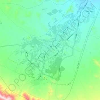
Nome: Mapa topográfico Eghlid, altitude, relevo.
Altitude média: 2310 m
Altitude mínima: 2115 m
Altitude máxima: 2984 m
Faça uma doação
Prepare-se para a sua próxima aventura:
Como Associado da Amazon, este site recebe uma comissão sobre compras elegíveis sem custo adicional para si.
Outros mapas topográficos
Clique em um mapa para visualizar sua topografia, sua altitude e seu relevo.