
Mapa topográfico Zile
Mapa interativo
Clique no mapa para exibir a altitude.
Sobre este mapa
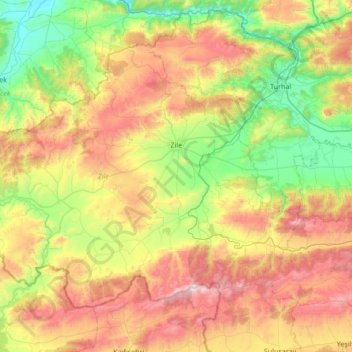
Nome: Mapa topográfico Zile, altitude, relevo.
Local: Zile, Tokat, Black Sea Region, 60400, Turkey (40.05922 35.43958 40.44936 36.11907)
Altitude média: 985 m
Altitude mínima: 423 m
Altitude máxima: 1897 m
Zile covers an area of 1,512 square kilometres (584 sq mi) within its city limits and has an elevation of 710 metres (2,330 ft).[15] Turhal, Çekerek, Artova, Kadışehri, and Amasya are all towns located near Zile. The city is mostly surrounded by a fertile plain called Zile Ovası crossed by the Yeşil River and can produce harvests twice a year. South of the city, however, are the Deveci Mountains (1,892 m / 6,207 ft high), Güvercin Çalı, and Hüseyin Gazi Hill. Zile once had a great forest covering most of the plain, but during the 1950s, the city lost much of its forest because of the excessive breeding of goats and the use of wood for heating purposes.[15] However, there is a recent study to plan reforestation in the area.[citation needed]
Outros mapas topográficos
Clique em um mapa para visualizar sua topografia, sua altitude e seu relevo.
Reşadiye Belediyesi
Reşadiye Belediyesi, Reşadiye, Tokat, Black Sea Region, Turkey
Altitude média: 749 m
Ekincik
Turkey > Tokat > Tokat Merkez
Ekincik, Tokat Merkez, Tokat, Black Sea Region, Turkey
Altitude média: 1004 m