
Mapa topográfico Ironville
Mapa interativo
Clique no mapa para exibir a altitude.
Sobre este mapa
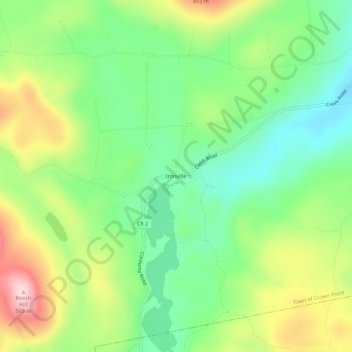
Nome: Mapa topográfico Ironville, altitude, relevo.
Altitude média: 326 m
Altitude mínima: 217 m
Altitude máxima: 501 m
Outros mapas topográficos
Clique em um mapa para visualizar sua topografia, sua altitude e seu relevo.
Burdick Crossing
United States > New York > Essex County > Town of Crown Point
Burdick Crossing, Town of Crown Point, Essex County, New York, 12928, United States
Altitude média: 41 m
Cold Spring Park
United States > New York > Essex County > Town of Crown Point
Cold Spring Park, Town of Crown Point, Essex County, New York, 12928, United States
Altitude média: 256 m
Crown Point Center
United States > New York > Essex County > Town of Crown Point
Crown Point Center, Town of Crown Point, Essex County, New York, 12928, United States
Altitude média: 158 m
Factoryville
United States > New York > Essex County > Town of Crown Point
Factoryville, Town of Crown Point, Essex County, New York, 12928, United States
Altitude média: 126 m