
Mapa topográfico Bodenfelde
Mapa interativo
Clique no mapa para exibir a altitude.
Sobre este mapa
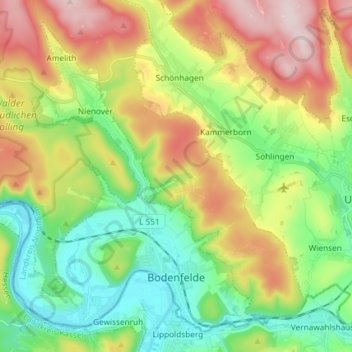
Nome: Mapa topográfico Bodenfelde, altitude, relevo.
Local: Bodenfelde, Landkreis Northeim, Lower Saxony, 37194, Germany (51.62452 9.45058 51.70501 9.59735)
Altitude média: 237 m
Altitude mínima: 96 m
Altitude máxima: 461 m
Outros mapas topográficos
Clique em um mapa para visualizar sua topografia, sua altitude e seu relevo.
Uslar
Germany > Lower Saxony > Landkreis Northeim
Uslar, Landkreis Northeim, Lower Saxony, 37170, Germany
Altitude média: 269 m
Dassel
Germany > Lower Saxony > Landkreis Northeim
Dassel, Landkreis Northeim, Lower Saxony, 37586, Germany
Altitude média: 277 m
Clus
Germany > Lower Saxony > Landkreis Northeim > Bad Gandersheim
Clus, Bad Gandersheim, Landkreis Northeim, Lower Saxony, 37581, Germany
Altitude média: 169 m
Balos
Germany > Lower Saxony > Landkreis Northeim > Moringen
Balos, Moringen, Landkreis Northeim, Lower Saxony, 37186, Germany
Altitude média: 293 m