
Mapa topográfico Dumont
Clique no mapa para exibir a altitude.
Sobre este mapa
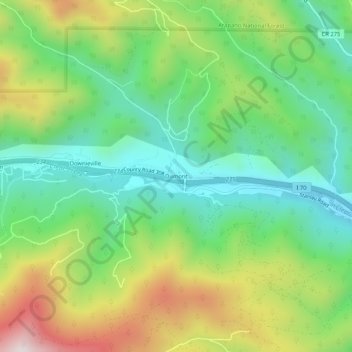
Nome: Mapa topográfico Dumont, altitude, relevo.
Local: Dumont, Clear Creek County, Colorado, 80436, United States (39.74469 -105.62034 39.78469 -105.58034)
Altitude média: 2672 m
Altitude mínima: 2382 m
Altitude máxima: 3186 m
Outros mapas topográficos
Clique em um mapa para visualizar sua topografia, sua altitude e seu relevo.
Georgetown
United States > Colorado > Clear Creek County
The town sits at an elevation of 8,530 feet (2,600 m) above sea level, nestled in the mountains near the upper end of the valley of Clear Creek in the mountains west of Denver along Interstate 70. Although population was only about 1,000 at the 2010 census, the town was a historic center of the mining industry…
Altitude média: 2974 m