
Mapa topográfico Bicester
Mapa interativo
Clique no mapa para exibir a altitude.
Sobre este mapa
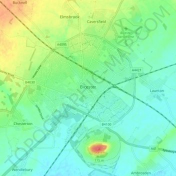
Nome: Mapa topográfico Bicester, altitude, relevo.
Altitude média: 76 m
Altitude mínima: 60 m
Altitude máxima: 114 m
Bicester has expanded rapidly in recent generations due to the town's picturesque historical town centre, garden town, independent and high-street shops, restaurants, and excellent rail connections to Oxford and its imminent connection to Cambridge, as well as rail links to Birmingham and London. It is similarly proximate to Brackley, Buckingham, Banbury, Milton Keynes, and Aylesbury. A considerable volume of high quality and environmentally friendly housing stock has been constructed recently, in particular at the Elmsbrook eco-town and the self-build homes at Graven Hill. Its flat topography and compact size is suited to walking and cycling, which, together with an active cycle campaign, has attracted a significant focus on developing improved active travel infrastructure, including the majority of a recent £14 million central government award to Oxfordshire County Council dedicated to safer walking and cycling.
Outros mapas topográficos
Clique em um mapa para visualizar sua topografia, sua altitude e seu relevo.
Hornton
United Kingdom > England > Oxfordshire > Cherwell District
Hornton, Cherwell District, Oxfordshire, England, United Kingdom
Altitude média: 172 m
Juniper Hill
United Kingdom > England > Oxfordshire > Cherwell District > Cottisford
Juniper Hill, Cottisford, Cherwell District, Oxfordshire, England, NN13 5RN, United Kingdom
Altitude média: 126 m
Bletchingdon
United Kingdom > England > Oxfordshire > Cherwell District
Bletchingdon, Cherwell District, Oxfordshire, England, United Kingdom
Altitude média: 76 m
Duns Tew
United Kingdom > England > Oxfordshire > Cherwell District
Duns Tew, Cherwell District, Oxfordshire, England, United Kingdom
Altitude média: 125 m
Banbury
United Kingdom > England > Oxfordshire > Cherwell District
Banbury, Cherwell District, Oxfordshire, England, United Kingdom
Altitude média: 116 m