
Mapa topográfico Bir
Mapa interativo
Clique no mapa para exibir a altitude.
Sobre este mapa
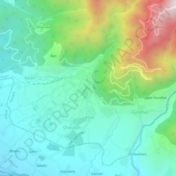
Nome: Mapa topográfico Bir, altitude, relevo.
Altitude média: 1628 m
Altitude mínima: 1284 m
Altitude máxima: 2560 m
The paragliding launch site is in the meadow at Billing (14 km north of Bir), at an elevation of 2400 meters, while the landing site and most tourist accommodations are in the village of Chowgan (also spelled Chaugan), on the southern edge of Bir.
Outros mapas topográficos
Clique em um mapa para visualizar sua topografia, sua altitude e seu relevo.
Phatt
India > Himachal Pradesh > Baijnath > Kotli
Phatt, Kotli, Baijnath, Kangra District, Himachal Pradesh, 176077, India
Altitude média: 1569 m
sakri khas
India > Himachal Pradesh > Baijnath > Langhu
sakri khas, Langhu, Baijnath, Kangra, Himachal Pradesh, 176128, India
Altitude média: 900 m