
Mapa topográfico Logan
Mapa interativo
Clique no mapa para exibir a altitude.
Logan
The city lies near the eastern edge of Cache Valley on the western slopes of the Bear River Mountains. Mount Logan rises to an elevation of 9,710 feet (2,960 m) immediately to the east, and south of Logan Canyon. The eastern portions of the city are constructed on top of shelf-like "benches", late Pleistocene sedimentary deposits created by the glacially fed Logan River feeding into the northern stretches of Lake Bonneville, building a "Gilbert-type" river delta over several thousand years. The Logan River later cut down through these sedimentary deposits following the draining of Lake Bonneville approximately 14,500 years ago. This created a low-lying area with very steep slopes that reach into the rest of town and to the Logan River bottomlands. To the west of Logan lie flatlands that contain both farmland and marshes. To the north and south of Logan are rapidly growing residential suburbs.
Sobre este mapa
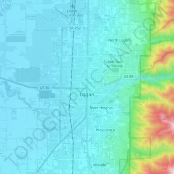
Nome: Mapa topográfico Logan, altitude, relevo.
Local: Logan, Cache County, Utah, United States (41.67538 -111.90194 41.79736 -111.78019)
Altitude média: 1498 m
Altitude mínima: 1342 m
Altitude máxima: 2659 m
Outros mapas topográficos
Clique em um mapa para visualizar sua topografia, sua altitude e seu relevo.