
Mapa topográfico Whites Bay
Mapa interativo
Clique no mapa para exibir a altitude.
Sobre este mapa
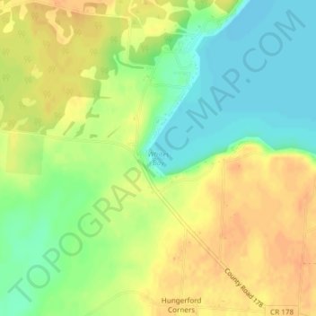
Nome: Mapa topográfico Whites Bay, altitude, relevo.
Altitude média: 91 m
Altitude mínima: 72 m
Altitude máxima: 107 m
Outros mapas topográficos
Clique em um mapa para visualizar sua topografia, sua altitude e seu relevo.
Village of Evans Mills
United States > New York > Jefferson County
Village of Evans Mills, Town of Le Ray, Jefferson County, New York, United States
Altitude média: 139 m
Just Room Enough Island
United States > New York > Jefferson County > Village of Alexandria Bay
Just Room Enough Island, Village of Alexandria Bay, Town of Alexandria, Jefferson County, New York, United States
Altitude média: 78 m
Town of Watertown
United States > New York > Jefferson County
Town of Watertown, Jefferson County, New York, United States
Altitude média: 189 m
Village of Black River
United States > New York > Jefferson County
Village of Black River, Town of Le Ray, Jefferson County, New York, United States
Altitude média: 193 m
Village of Philadelphia
United States > New York > Jefferson County
Village of Philadelphia, Town of Philadelphia, Jefferson County, New York, 13673, United States
Altitude média: 149 m
Village of Theresa
United States > New York > Jefferson County > Town of Theresa
Village of Theresa, Town of Theresa, Jefferson County, New York, 13691, United States
Altitude média: 121 m
Black River
United States > New York > Jefferson County > Black River
Black River, Le Ray, Jefferson County, New York, 13612, United States
Altitude média: 189 m