
Faça uma doação
Prepare-se para a sua próxima aventura:
Como Associado da Amazon, este site recebe uma comissão sobre compras elegíveis sem custo adicional para si.
Mapa topográfico Whiskey Run Beach
Clique no mapa para exibir a altitude.
Faça uma doação
Prepare-se para a sua próxima aventura:
Como Associado da Amazon, este site recebe uma comissão sobre compras elegíveis sem custo adicional para si.
Sobre este mapa
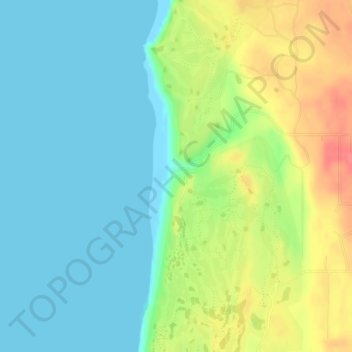
Nome: Mapa topográfico Whiskey Run Beach, altitude, relevo.
Local: Whiskey Run Beach, Coos County, Oregon, United States (43.21034 -124.39433 43.21044 -124.39423)
Altitude média: 22 m
Altitude mínima: -1 m
Altitude máxima: 65 m
Faça uma doação
Prepare-se para a sua próxima aventura:
Como Associado da Amazon, este site recebe uma comissão sobre compras elegíveis sem custo adicional para si.
Outros mapas topográficos
Clique em um mapa para visualizar sua topografia, sua altitude e seu relevo.
Coos Bay
United States > Oregon > Coos County
According to the United States Census Bureau, the city has a total area of 15.90 square miles (41.18 km2), of which, 10.60 square miles (27.45 km2) is land and 5.30 square miles (13.73 km2) is water. The city is quite hilly, with elevations ranging from between sea level to over 500 feet (150 m). Bodies of…
Altitude média: 30 m
Faça uma doação
Prepare-se para a sua próxima aventura:
Como Associado da Amazon, este site recebe uma comissão sobre compras elegíveis sem custo adicional para si.