
Mapa topográfico Kanigund
Mapa interativo
Clique no mapa para exibir a altitude.
Sobre este mapa
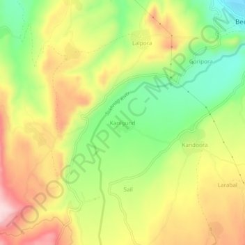
Nome: Mapa topográfico Kanigund, altitude, relevo.
Altitude média: 1858 m
Altitude mínima: 1720 m
Altitude máxima: 2001 m
Outros mapas topográficos
Clique em um mapa para visualizar sua topografia, sua altitude e seu relevo.
Qumroo
India > Jammu and Kashmir > Beerwah tehsil
Qumroo, Beerwah tehsil, Budgam District, Jammu and Kashmir, India
Altitude média: 2000 m
Ohangam
India > Jammu and Kashmir > Beerwah tehsil
Ohangam, Beerwah tehsil, Budgam District, Jammu and Kashmir, 193401, India
Altitude média: 1705 m