
Mapa topográfico Crawinkel
Mapa interativo
Clique no mapa para exibir a altitude.
Sobre este mapa
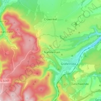
Nome: Mapa topográfico Crawinkel, altitude, relevo.
Local: Crawinkel, Ohrdruf, Landkreis Gotha, Thüringen, Deutschland (50.71792 10.72425 50.79626 10.82820)
Altitude média: 536 m
Altitude mínima: 366 m
Altitude máxima: 770 m
Zu Crawinkel bemerkt Galletti in seiner topographisch-historischen Beschreibung des Gothaer Herzogtums von 1780:
Outros mapas topográficos
Clique em um mapa para visualizar sua topografia, sua altitude e seu relevo.
Wölfis
Deutschland > Thüringen > Landkreis Gotha > Ohrdruf
Wölfis, Ohrdruf, Landkreis Gotha, Thüringen, 99885, Deutschland
Altitude média: 443 m