
Mapa topográfico Pingbian
Mapa interativo
Clique no mapa para exibir a altitude.
Sobre este mapa
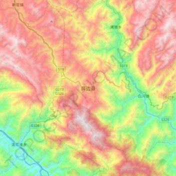
Nome: Mapa topográfico Pingbian, altitude, relevo.
Altitude média: 1167 m
Altitude mínima: 106 m
Altitude máxima: 2322 m
Pingbian County has a mild subtropical highland climate (Köppen Cwb) influenced by its elevation, with short, mild, dry winters and warm, humid summers. The monthly 24-hour average temperature ranges from 9.2 °C (48.6 °F) in January to 21.3 °C (70.3 °F) in July, and the annual mean is 16.3 °C (61.3 °F). The greatest rainfall tends to occur during the summer; spring is the sunniest season.