
Mapa topográfico White City
Mapa interativo
Clique no mapa para exibir a altitude.
Sobre este mapa
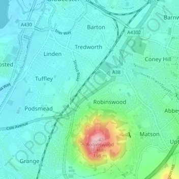
Nome: Mapa topográfico White City, altitude, relevo.
Altitude média: 38 m
Altitude mínima: 7 m
Altitude máxima: 191 m
Outros mapas topográficos
Clique em um mapa para visualizar sua topografia, sua altitude e seu relevo.
North Matson
United Kingdom > England > Gloucestershire > Gloucester
North Matson, Gloucester, Gloucestershire, England, United Kingdom
Altitude média: 52 m
Kings Barton
United Kingdom > England > Gloucestershire > Gloucester
Kings Barton, Gloucester, Gloucestershire, England, GL1 1QT, United Kingdom
Altitude média: 20 m
Lower Rea
United Kingdom > England > Gloucestershire > Gloucester
Lower Rea, Quedgeley, Gloucester, Gloucestershire, England, GL2 3NW, United Kingdom
Altitude média: 17 m
Saint Leonards Park
United Kingdom > England > Gloucestershire > Gloucester
Saint Leonards Park, Gloucester, Gloucestershire, England, GL4 6JX, United Kingdom
Altitude média: 72 m
Quedgeley
United Kingdom > England > Gloucestershire > Gloucester
Quedgeley, Gloucester, Gloucestershire, England, United Kingdom
Altitude média: 20 m
Abbeymead Contour Park
United Kingdom > England > Gloucestershire > Gloucester
Abbeymead Contour Park, Abbeydale, Gloucester, Gloucestershire, England, United Kingdom
Altitude média: 46 m