
Faça uma doação
Prepare-se para a sua próxima aventura:
Como Associado da Amazon, este site recebe uma comissão sobre compras elegíveis sem custo adicional para si.
Mapa topográfico Devils Elbow
Clique no mapa para exibir a altitude.
Faça uma doação
Prepare-se para a sua próxima aventura:
Como Associado da Amazon, este site recebe uma comissão sobre compras elegíveis sem custo adicional para si.
Sobre este mapa
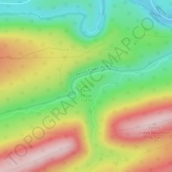
Nome: Mapa topográfico Devils Elbow, altitude, relevo.
Altitude média: 387 m
Altitude mínima: 235 m
Altitude máxima: 564 m
Faça uma doação
Prepare-se para a sua próxima aventura:
Como Associado da Amazon, este site recebe uma comissão sobre compras elegíveis sem custo adicional para si.
Outros mapas topográficos
Clique em um mapa para visualizar sua topografia, sua altitude e seu relevo.
Faça uma doação
Prepare-se para a sua próxima aventura:
Como Associado da Amazon, este site recebe uma comissão sobre compras elegíveis sem custo adicional para si.
Faça uma doação
Prepare-se para a sua próxima aventura:
Como Associado da Amazon, este site recebe uma comissão sobre compras elegíveis sem custo adicional para si.
Faça uma doação
Prepare-se para a sua próxima aventura:
Como Associado da Amazon, este site recebe uma comissão sobre compras elegíveis sem custo adicional para si.
Faça uma doação
Prepare-se para a sua próxima aventura:
Como Associado da Amazon, este site recebe uma comissão sobre compras elegíveis sem custo adicional para si.
Faça uma doação
Prepare-se para a sua próxima aventura:
Como Associado da Amazon, este site recebe uma comissão sobre compras elegíveis sem custo adicional para si.
Mill Run
United States > Pennsylvania > Blair County > Altoona > Allegheny Furnace
Altitude média: 349 m
Faça uma doação
Prepare-se para a sua próxima aventura:
Como Associado da Amazon, este site recebe uma comissão sobre compras elegíveis sem custo adicional para si.
Martin's Creek
United States > Pennsylvania > Northampton County > Lower Mount Bethel Township > Martins Creek
Altitude média: 152 m
Faça uma doação
Prepare-se para a sua próxima aventura:
Como Associado da Amazon, este site recebe uma comissão sobre compras elegíveis sem custo adicional para si.
Sullivan County
Elevation ranges from 2593 ft at North Mountain in Davidson Township to 779 ft on Loyalsock Creek at the Lycoming County line. The county is served by Pennsylvania Route 42, Pennsylvania Route 87, Pennsylvania Route 154, Pennsylvania Route 487, and U.S. Route 220. The major rivers in the county are Loyalsock…
Altitude média: 491 m
Faça uma doação
Prepare-se para a sua próxima aventura:
Como Associado da Amazon, este site recebe uma comissão sobre compras elegíveis sem custo adicional para si.
Faça uma doação
Prepare-se para a sua próxima aventura:
Como Associado da Amazon, este site recebe uma comissão sobre compras elegíveis sem custo adicional para si.
Faça uma doação
Prepare-se para a sua próxima aventura:
Como Associado da Amazon, este site recebe uma comissão sobre compras elegíveis sem custo adicional para si.
Chester
United States > Pennsylvania > Delaware County > Chester
Being at a low elevation between Philadelphia and Wilmington, Chester experiences a humid subtropical climate (Cfa.) The hardiness zone is 7b. Archived 2014-02-09 at the Wayback Machine
Altitude média: 10 m
Bob Case Park
United States > Pennsylvania > Montgomery County > Upper Merion Township > King of Prussia > Sweet Briar
Altitude média: 45 m
Faça uma doação
Prepare-se para a sua próxima aventura:
Como Associado da Amazon, este site recebe uma comissão sobre compras elegíveis sem custo adicional para si.
Townville
United States > Pennsylvania > Crawford County
The borough is in a valley at the height of land between north-flowing Muddy Creek and south-flowing Sugar Creek, both tributaries of French Creek and part of the Allegheny River watershed. The lowest elevation in Townville is 1,370 ft (420 m) on the southern boundary at the wetland that is drained by Muddy…
Altitude média: 450 m
Moosic
United States > Pennsylvania > Moosic
Moosic is located in the Wyoming Valley of northeastern Pennsylvania. In terms of physiography, Moosic is part of the Ridge and Valley province of the Appalachian Mountains. Moosic is located at an elevation of 817 feet (249 m) above sea level. The major body of water flowing through the borough is the…
Altitude média: 246 m
Faça uma doação
Prepare-se para a sua próxima aventura:
Como Associado da Amazon, este site recebe uma comissão sobre compras elegíveis sem custo adicional para si.
Faça uma doação
Prepare-se para a sua próxima aventura:
Como Associado da Amazon, este site recebe uma comissão sobre compras elegíveis sem custo adicional para si.
King of Prussia
United States > Pennsylvania > Montgomery County > King of Prussia
Altitude média: 59 m
South Strabane Township
United States > Pennsylvania > Washington County > South Strabane Township
Altitude média: 358 m
Faça uma doação
Prepare-se para a sua próxima aventura:
Como Associado da Amazon, este site recebe uma comissão sobre compras elegíveis sem custo adicional para si.
Willow Grove
United States > Pennsylvania > Montgomery County > Upper Moreland Township > Willow Grove
Altitude média: 88 m
Tamaqua
United States > Pennsylvania > Schuylkill County
Tamaqua's average elevation is 870 feet (270 m) above sea level, but elevations can reach up to 1,000 feet (300 m) above sea level.
Altitude média: 352 m
Faça uma doação
Prepare-se para a sua próxima aventura:
Como Associado da Amazon, este site recebe uma comissão sobre compras elegíveis sem custo adicional para si.
Brackenridge
United States > Pennsylvania > Allegheny County
Brackenridge is located at 40°36′30″N 79°44′32″W / 40.60833°N 79.74222°W / 40.60833; -79.74222. The borough's average elevation is 827 feet (252 m) above sea level.
Altitude média: 266 m
Faça uma doação
Prepare-se para a sua próxima aventura:
Como Associado da Amazon, este site recebe uma comissão sobre compras elegíveis sem custo adicional para si.