
Mapa topográfico Gauchar
Mapa interativo
Clique no mapa para exibir a altitude.
Sobre este mapa
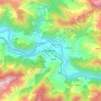
Nome: Mapa topográfico Gauchar, altitude, relevo.
Altitude média: 1196 m
Altitude mínima: 677 m
Altitude máxima: 2125 m
Gauchar (Garhwali: Gòchàr ) is a Hill Town sort of a valley town located in Karnaprayag tehsil within Chamoli district of Uttarakhand state in India. Gauchar is situated on the left bank of river Alaknanda and is en route to the celebrated holy destination of Badrinath. It is well known for being one of the cleanest place in country. It has previously topped Swachta sarvekshan best ganga town award. Situated at an altitude of 800 metres (2,620 ft) above the sea level, Gauchar is surrounded by seven mountains. Gauchar is well known for its historic trade fair and airstrip. Gauchar town known for its great work to curb loss of lives in 2013 flood disaster of Uttarakhand. This town is unique in terms of its geographical location and topography. Gauchar is located on one of the largest pieces of flatland in this mountainous region of Uttarakhand. Education institution in Gauchar includes a beautiful Kendriya Vidyalaya adjacent to the main playground.
Outros mapas topográficos
Clique em um mapa para visualizar sua topografia, sua altitude e seu relevo.
Khoti
India > Uttarakhand > Karnaprayag
Khoti, Karnaprayag, Chamoli district, Uttarakhand, 246440, India
Altitude média: 1842 m
Ghandiyal
India > Uttarakhand > Karnaprayag
Ghandiyal, Karnaprayag, Chamoli district, Uttarakhand, India
Altitude média: 1748 m
Karnaprayag
India > Uttarakhand > Karnaprayag
Karnaprayag, Chamoli district, Uttarakhand, 246444, India
Altitude média: 1273 m
Jalgaon
India > Uttarakhand > Karnaprayag > Jalgaon
Jalgaon, Karnaprayag, Chamoli district, Uttarakhand, India
Altitude média: 1822 m