
Mapa topográfico Mansfield
Mapa interativo
Clique no mapa para exibir a altitude.
Sobre este mapa
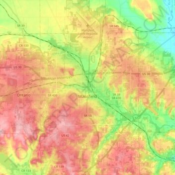
Nome: Mapa topográfico Mansfield, altitude, relevo.
Local: Mansfield, Richland County, Ohio, United States (40.68864 -82.59004 40.84363 -82.45608)
Altitude média: 387 m
Altitude mínima: 302 m
Altitude máxima: 461 m
Mansfield is located at 40°45′17″N 82°31′22″W / 40.75472°N 82.52278°W / 40.75472; -82.52278 (40.754856, −82.522855), directly between Columbus and Cleveland, however, the city lies in the western foothills of the Allegheny Plateau, and its elevation is among the highest of Ohio cities. The highest point in the city 1,493 feet (455 m) above sea level is located at the Woodland Reservoir, an underground water storage (service reservoir) along Woodland Road in southwest Mansfield. The elevation in downtown Mansfield, which is located at Central Park is 1,240 feet (378 m) above sea level, and at Mansfield Lahm Airport, the elevation is 1,293 feet (394 m) above sea level. The highest point in Richland County, second highest point in Ohio (after Campbell Hill) is between 1,510 feet (460 m) and 1,520 feet (463 m) above sea level is located southwest of the city, just off Lexington-Ontario Road at Apple Hill Orchards in Springfield Township.
Outros mapas topográficos
Clique em um mapa para visualizar sua topografia, sua altitude e seu relevo.
Lexington
United States > Ohio > Richland County
Lexington, Troy Township, Richland County, Ohio, United States
Altitude média: 386 m
South Boulevards
United States > Ohio > Richland County > Mansfield
South Boulevards, Mansfield, Richland County, Ohio, 44907, United States
Altitude média: 421 m
Shelby
United States > Ohio > Richland County > Shelby
Shelby, Sharon Township, Richland County, Ohio, 44875, United States
Altitude média: 336 m
Ontario
United States > Ohio > Richland County
Ontario, Springfield Township, Richland County, Ohio, United States
Altitude média: 408 m