
Mapa topográfico Udaipur
Mapa interativo
Clique no mapa para exibir a altitude.
Sobre este mapa
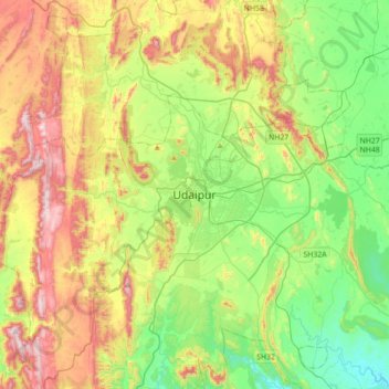
Nome: Mapa topográfico Udaipur, altitude, relevo.
Altitude média: 656 m
Altitude mínima: 408 m
Altitude máxima: 1067 m
Udaipur is located at 24°31′30″N 73°40′38″E / 24.525049°N 73.677116°E / 24.525049; 73.677116. The city covers an area of 64 km2 (25 sq mi) and lies at an altitude of 598.00 m (1,962 ft) above sea level. It is located in the southern region of Rajasthan, near the Gujarat border. The city lies 403 km (250 mi) southwest of the state capital, Jaipur and 250 km (155 mi) northeast from Ahmedabad.
Outros mapas topográficos
Clique em um mapa para visualizar sua topografia, sua altitude e seu relevo.
Kalarwas
India > Rajasthan > Girwa Tehsil
Kalarwas, Girwa Tehsil, Udaipur District, Rajasthan, India
Altitude média: 583 m
Pratap Park
India > Rajasthan > Girwa Tehsil > Udaipur
Pratap Park, Udaipur, Girwa Tehsil, Udaipur District, Rajasthan, 313001, India
Altitude média: 608 m
Kodiyat
India > Rajasthan > Girwa Tehsil
Kodiyat, Girwa Tehsil, Udaipur District, Rajasthan, India
Altitude média: 672 m