
Mapa topográfico Ankara
Mapa interativo
Clique no mapa para exibir a altitude.
Sobre este mapa
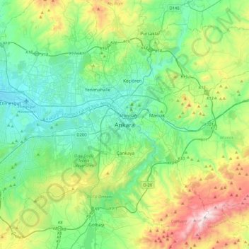
Nome: Mapa topográfico Ankara, altitude, relevo.
Altitude média: 1082 m
Altitude mínima: 798 m
Altitude máxima: 1864 m
Ankara has a cold semi-arid climate (Köppen climate classification: BSk). Under the Trewartha climate classification, Ankara has a temperate humid continental climate (Dc). Due to its elevation and inland location, Ankara has cold and snowy winters, and hot and dry summers. Rainfall occurs mostly during the spring and autumn. The city lies in USDA Hardiness zone 7b, and its annual average precipitation is fairly low at 414 millimeters (16 in), nevertheless precipitation can be observed throughout the year. Monthly mean temperatures range from 0.9 °C (33.6 °F) in January to 24.3 °C (75.7 °F) in July, with an annual mean of 12.6 °C (54.7 °F).
Outros mapas topográficos
Clique em um mapa para visualizar sua topografia, sua altitude e seu relevo.
Kocatepe Mahallesi
Kocatepe Mahallesi, Çankaya, Ankara, Central Anatolia Region, 06660, Turkey
Altitude média: 896 m
Harbiye Mahallesi
Harbiye Mahallesi, Çankaya, Ankara, Central Anatolia Region, Turkey
Altitude média: 1004 m
Koru Mahallesi
Koru Mahallesi, Çankaya, Ankara, Central Anatolia Region, Turkey
Altitude média: 900 m
Çayyolu Mahallesi
Çayyolu Mahallesi, Çankaya, Ankara, Central Anatolia Region, Turkey
Altitude média: 921 m
Ayrancı Mahallesi
Ayrancı Mahallesi, Çankaya, Ankara, Central Anatolia Region, Turkey
Altitude média: 975 m