
Mapa topográfico Shenyang City
Mapa interativo
Clique no mapa para exibir a altitude.
Sobre este mapa
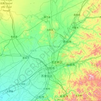
Nome: Mapa topográfico Shenyang City, altitude, relevo.
Local: Shenyang City, Liaoning, China (41.19769 122.41674 43.04030 123.80854)
Altitude média: 151 m
Altitude mínima: 3 m
Altitude máxima: 1084 m
Shenyang ranges in latitude from 41° 11' to 43° 02' N and in longitude from 122° 25' to 123° 48' E, and is located in the central part of Liaoning province. The western parts of the city's administrative area are located on the alluvial plain of the Liao River system, while the eastern part consists of the hinterlands of the Changbai Mountains, and is covered with forests. The highest point in Shenyang is 414 m (1,358 ft) above sea level and the lowest point only 7 m (23 ft). The average elevation of the urban area is 45 m (148 ft).
Outros mapas topográficos
Clique em um mapa para visualizar sua topografia, sua altitude e seu relevo.
Blliuhe Reservoir
China > Liaoning > Pulandian District
Blliuhe Reservoir, Pulandian District, Dalian City, Liaoning, China
Altitude média: 134 m
Xiaonan
China > Liaoning > Lüshunkou District
Xiaonan, Lüshunkou District, Dalian City, Liaoning, China
Altitude média: 40 m
Changhai County
Changhai County, Dalian City, Liaoning, 116500, China
Altitude média: 2 m
Anshan
China > Liaoning > Shengli Subdistrict
Anshan, Shengli Subdistrict, Tiedong District, Anshan City, Liaoning, China
Altitude média: 79 m
Anshan
China > Liaoning > Anshan > Shengli Subdistrict
Anshan, Shengli Subdistrict, Tiedong District, Anshan City, Liaoning, China
Altitude média: 79 m
Hunnan District
China > Liaoning > Shenyang City
Hunnan District, Shenyang City, Liaoning, China
Altitude média: 92 m