
Mapa topográfico Lead
Mapa interativo
Clique no mapa para exibir a altitude.
Sobre este mapa
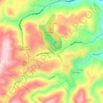
Nome: Mapa topográfico Lead, altitude, relevo.
Local: Lead, Lawrence County, South Dakota, United States (44.34184 -103.78764 44.36313 -103.73826)
Altitude média: 1605 m
Altitude mínima: 1417 m
Altitude máxima: 1764 m
Its high elevation in the Black Hills makes Lead one of the wettest places in South Dakota and among the snowiest places in the contiguous United States with a mean snowfall of 183.9 inches or 4.67 metres.[17][18] During the cold and snowy winter of 1993–94, a whopping 364.7 inches (9.26 m) of snow fell and three years later snowfall totalled 324.0 inches (8.23 m).[17] However, frequent chinook winds mean that most of the enormous snowfall melts during the winter: the highest snow cover on record is 73 inches (1.85 m) on March 1, 1998 – during a storm that totalled 114.6 inches or 2.91 metres of snow (water equivalent 4.12 inches or 104.6 millimetres) over six days ending March 2. Mean snow depth in January is only 7 inches or 0.18 metres and the median even less at 5 inches or 0.13 metres. 12.9 mornings can be expected to fall to or below 0 °F (−17.8 °C), with the average window for zero temperatures being December 7 to March 3; on the other hand during winter 12.8 afternoons can be expected to get to or above 50 °F or 10 °C.[17] The coldest temperature has been −40 °F or −40 °C on February 8, 1936.[17]
Outros mapas topográficos
Clique em um mapa para visualizar sua topografia, sua altitude e seu relevo.
Spearfish
United States > South Dakota > Lawrence County
Spearfish, Lawrence County, South Dakota, United States
Altitude média: 1171 m
Deadwood
United States > South Dakota > Lawrence County
Deadwood, Lawrence County, South Dakota, 57732, United States
Altitude média: 1511 m
Savoy
United States > South Dakota > Lawrence County
Savoy, Lawrence County, South Dakota, United States
Altitude média: 1665 m
Terry Peak
United States > South Dakota > Lawrence County
Terry Peak, Lawrence County, South Dakota, United States
Altitude média: 1940 m
Cheyenne Crossing
United States > South Dakota > Lawrence County
Cheyenne Crossing, Lawrence County, South Dakota, United States
Altitude média: 1784 m
Bridal Veil Falls
United States > South Dakota > Lawrence County
Bridal Veil Falls, Lawrence County, South Dakota, United States
Altitude média: 1502 m
Spearfish
United States > South Dakota > Lawrence County > Spearfish
Spearfish, Lawrence County, South Dakota, 57783, United States
Altitude média: 1291 m