
Mapa topográfico Imst
Mapa interativo
Clique no mapa para exibir a altitude.
Sobre este mapa
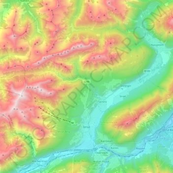
Nome: Mapa topográfico Imst, altitude, relevo.
Local: Imst, Bezirk Imst, 6460, Austria (47.21095 10.53837 47.34094 10.77582)
Altitude média: 1485 m
Altitude mínima: 666 m
Altitude máxima: 2744 m
Imst (German: [ɪmst] ; Southern Bavarian: Imscht) is a town in the Austrian federal state of Tyrol. It lies on the River Inn in western Tyrol, some 50 kilometres (31 miles) west of Innsbruck and at an altitude of 828 metres (2,717 feet) above sea level. With a current population (2018) of 10,504, Imst is the administrative centre of Imst District.
Outros mapas topográficos
Clique em um mapa para visualizar sua topografia, sua altitude e seu relevo.
Habichen
Austria > Bezirk Imst > Oetz
Habichen, Oetz, Bezirk Imst, 6433, Austria
Altitude média: 1305 m
Habicher See
Austria > Bezirk Imst > Oetz > Habichen
Habicher See, Habichen, Oetz, Bezirk Imst, 6433, Austria
Altitude média: 1148 m
Obergurgl
Austria > Bezirk Imst > Sölden
Obergurgl, Sölden, Bezirk Imst, 6456, Austria
Altitude média: 2324 m