
Mapa topográfico Town of Danby
Mapa interativo
Clique no mapa para exibir a altitude.
Sobre este mapa
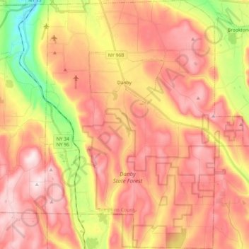
Nome: Mapa topográfico Town of Danby, altitude, relevo.
Local: Town of Danby, Tompkins County, New York, United States (42.26275 -76.53851 42.39654 -76.39437)
Altitude média: 404 m
Altitude mínima: 134 m
Altitude máxima: 586 m
Elevations range from approximately 450 feet above sea level where Cayuga Inlet crosses the northern town line, to about 1230 feet at Town Hall in Danby Hamlet, to just over 1800 feet at Dawes Hill in the southwestern part of the town and Roundtop in the southeastern part of the town. The dramatic hill and valley lands of Danby have sometimes been referred to as the 'Danby Highlands'.
Outros mapas topográficos
Clique em um mapa para visualizar sua topografia, sua altitude e seu relevo.
City of Ithaca
United States > New York > Tompkins County
City of Ithaca, Tompkins County, New York, United States
Altitude média: 195 m
Town of Newfield
United States > New York > Tompkins County
Town of Newfield, Tompkins County, New York, 14867, United States
Altitude média: 426 m
Buttermilk Falls State Park
United States > New York > Tompkins County > Ithaca > Town of Danby
Buttermilk Falls State Park, Ithaca, Town of Danby, Tompkins County, New York, United States
Altitude média: 269 m
East Ithaca
United States > New York > Tompkins County > Ithaca > East Ithaca
East Ithaca, Ithaca, Tompkins County, New York, United States
Altitude média: 281 m
Town of Ithaca
United States > New York > Tompkins County
Town of Ithaca, Tompkins County, New York, United States
Altitude média: 288 m
Town of Dryden
United States > New York > Tompkins County
Town of Dryden, Tompkins County, New York, United States
Altitude média: 430 m
Waterburg
United States > New York > Tompkins County > Waterburg
Waterburg, Ulysses Town, Tompkins County, New York, 14886, United States
Altitude média: 318 m