
Mapa topográfico Ingham County
Mapa interativo
Clique no mapa para exibir a altitude.
Sobre este mapa
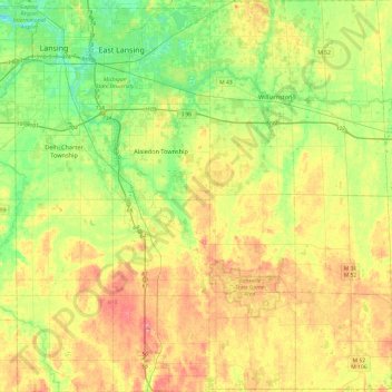
Nome: Mapa topográfico Ingham County, altitude, relevo.
Local: Ingham County, Michigan, United States of America (42.42196 -84.60314 42.77660 -84.14060)
Altitude média: 278 m
Altitude mínima: 246 m
Altitude máxima: 319 m
The county consists of gently rolling hills with an elevation ranging between 800 and 1,000 feet above sea level. The highest point in the county is the top of Teaspoon Hill rising to a height of 1,056 feet above sea level 1.5 miles north of Leslie.
Outros mapas topográficos
Clique em um mapa para visualizar sua topografia, sua altitude e seu relevo.
Genesee County
United States of America > Michigan
Genesee County, Michigan, United States of America
Altitude média: 246 m
Ontonagon County
United States of America > Michigan
Ontonagon County, Michigan, United States of America
Altitude média: 334 m
Sanilac County
United States of America > Michigan
Sanilac County, Michigan, United States of America
Altitude média: 228 m
East Lansing
United States of America > Michigan > East Lansing > East Lansing
East Lansing, Ingham County, Michigan, United States of America
Altitude média: 261 m