
Mapa topográfico Essex County
Mapa interativo
Clique no mapa para exibir a altitude.
Sobre este mapa
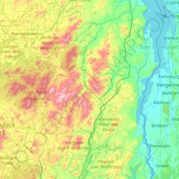
Nome: Mapa topográfico Essex County, altitude, relevo.
Local: Essex County, New York, United States of America (43.74451 -74.33683 44.54861 -73.29338)
Altitude média: 418 m
Altitude mínima: 25 m
Altitude máxima: 1607 m
Essex County is in the northeastern part of New York state, just west of Vermont along the eastern boundary of the state. The eastern boundary of Essex County is Lake Champlain, which serves as the New York – Vermont border at an elevation of just under 100 feet (30.5 m). The highest natural point in New York, Mount Marcy at 5,344 feet (1,629 m), is in the town of Keene.
Outros mapas topográficos
Clique em um mapa para visualizar sua topografia, sua altitude e seu relevo.
Saratoga County
United States of America > New York
Saratoga County, New York, United States of America
Altitude média: 218 m
Farmingville
United States of America > New York
Farmingville, Suffolk County, New York, 11738, United States of America
Altitude média: 47 m
Queens
United States of America > New York > New York
Queens, New York, United States of America
Altitude média: 11 m
Saint Lawrence
United States of America > New York
Saint Lawrence, New York, United States of America
Altitude média: 239 m
Nassau County
United States of America > New York
Nassau County, New York, United States of America
Altitude média: 18 m
Allegany County
United States of America > New York
Allegany County, New York, United States of America
Altitude média: 561 m
Valley Stream
United States of America > New York > Valley Stream > Valley Stream
Valley Stream, Hempstead, Nassau County, New York, 11580, United States of America
Altitude média: 7 m
New York County
United States of America > New York > New York
New York County, New York, United States of America
Altitude média: 16 m