
Mapa topográfico Wenatchee
Mapa interativo
Clique no mapa para exibir a altitude.
Sobre este mapa
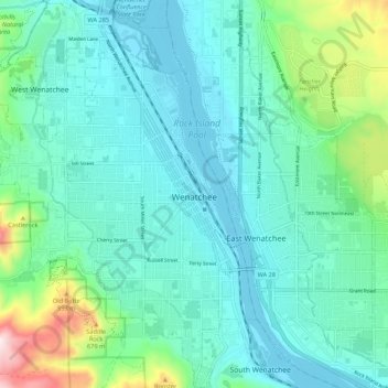
Nome: Mapa topográfico Wenatchee, altitude, relevo.
Local: Wenatchee, Chelan County, Washington, 98801, United States (47.38749 -120.36772 47.46056 -120.29281)
Altitude média: 302 m
Altitude mínima: 184 m
Altitude máxima: 807 m
Outros mapas topográficos
Clique em um mapa para visualizar sua topografia, sua altitude e seu relevo.
Entiat
United States > Washington > Chelan County
Entiat, Chelan County, Washington, United States
Altitude média: 376 m
Lake Wenatchee
United States > Washington > Chelan County
Lake Wenatchee, Chelan County, Washington, United States
Altitude média: 874 m
Dark Peak
United States > Washington > Chelan County
Dark Peak, Chelan County, Washington, United States
Altitude média: 2058 m
Plain
United States > Washington > Chelan County
Plain, Chelan County, Washington, United States
Altitude média: 673 m
Dragontail Peak
United States > Washington > Chelan County
Dragontail Peak, Chelan County, Washington, United States
Altitude média: 2235 m
Copper Peak
United States > Washington > Chelan County
Copper Peak, Chelan County, Washington, United States
Altitude média: 2032 m
Icicle Creek
United States > Washington > Chelan County
Icicle Creek, Chelan County, Washington, United States
Altitude média: 974 m
Labyrinth Mountain
United States > Washington > Chelan County
Labyrinth Mountain, Chelan County, Washington, United States
Altitude média: 1514 m
Bear Lake
United States > Washington > Chelan County
Bear Lake, Chelan County, Washington, United States
Altitude média: 1855 m
Sahale Glacier
United States > Washington > Chelan County
Sahale Glacier, Chelan County, Washington, United States
Altitude média: 2062 m