
Mapa topográfico Arendsee
Mapa interativo
Clique no mapa para exibir a altitude.
Sobre este mapa
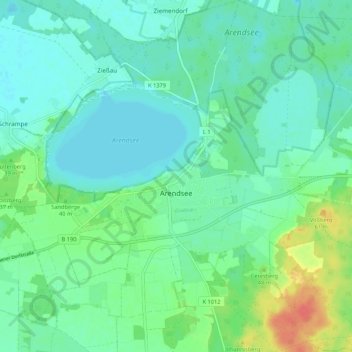
Nome: Mapa topográfico Arendsee, altitude, relevo.
Altitude média: 32 m
Altitude mínima: 19 m
Altitude máxima: 71 m
Outros mapas topográficos
Clique em um mapa para visualizar sua topografia, sua altitude e seu relevo.
Kleinau
Deutschland > Sachsen-Anhalt > Arendsee (Altmark) > Kleinau
Kleinau, Arendsee (Altmark), Altmarkkreis Salzwedel, Sachsen-Anhalt, Deutschland
Altitude média: 33 m
Schrampe
Deutschland > Sachsen-Anhalt > Arendsee (Altmark) > Schrampe
Schrampe, Arendsee (Altmark), Altmarkkreis Salzwedel, Sachsen-Anhalt, Deutschland
Altitude média: 26 m